Understanding USBL: How Ultra-Short Baseline Positioning Works in Underwater Navigation
Share
Abstract
Ultra-Short Baseline (USBL) technology is a critical tool for underwater positioning and navigation, commonly used in remotely operated vehicles (ROVs), autonomous underwater vehicles (AUVs), and commercial diving operations. By utilizing acoustic signals and time-delay measurements, USBL systems provide real-time positioning of underwater assets relative to a surface vessel or fixed station. This article explores the principles of USBL, its applications in marine industries, and its role in supporting underwater operations in New Zealand.
1. Introduction
Underwater navigation presents unique challenges due to the inability of GPS signals to penetrate water. Instead, acoustic positioning systems such as USBL, long baseline (LBL), and short baseline (SBL) are used to track subsea equipment, divers, and marine research platforms. USBL has gained prominence due to its high accuracy, ease of deployment, and real-time tracking capabilities, making it a preferred choice for offshore energy, marine research, and underwater construction projects.
New Zealand’s expanding offshore wind, aquaculture, and marine conservation industries rely on precise underwater positioning systems for efficient operations. USBL is a key technology in these sectors, ensuring accurate ROV navigation, diver safety, and subsea infrastructure inspections.
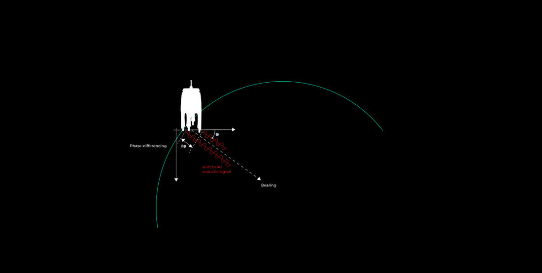
2. How USBL Works
2.1 Principles of USBL Positioning
USBL systems operate by transmitting and receiving acoustic signals between a transceiver on a vessel and a transponder underwater. The time it takes for the acoustic signal to travel between these two points is used to calculate the distance and position of the underwater object.
A USBL system consists of three primary components. The transceiver, mounted on the vessel, sends out and receives acoustic pulses. The transponder, attached to the ROV, diver, or AUV, reflects the acoustic signal back to the transceiver. The processing unit analyzes the time delay and angle of the returning signal to calculate the exact position of the underwater target.
The transceiver contains an array of hydrophones that detect incoming signals at slightly different times, allowing the system to determine range, bearing, and depth of the transponder.
2.2 USBL Signal Processing and Position Calculation
The accuracy of USBL positioning is based on two key factors. Time delay measurement calculates the time it takes for the signal to travel between the transceiver and transponder. Angle of arrival, or phase differencing, is measured by multiple hydrophones detecting small differences in the arrival time of the returning signal, allowing the system to triangulate the underwater position.
By integrating motion sensors such as inertial navigation systems and GPS data, USBL systems can compensate for vessel movement, improving accuracy in dynamic ocean conditions.
3. Applications of USBL in Marine Industries
3.1 ROV and AUV Tracking
USBL is widely used in offshore operations to track and guide ROVs and AUVs performing tasks such as underwater inspections, maintenance, and mapping. In deep-sea environments where visual tracking is impossible, USBL provides a reliable positioning solution for remotely operated vehicles.
New Zealand's marine infrastructure projects, including offshore wind farms and subsea cable installations, use USBL-equipped ROVs to conduct seabed surveys and maintenance inspections.
3.2 Commercial Diving Support
For scientific and commercial divers, USBL enhances safety and efficiency by providing real-time diver tracking. Surface teams can monitor a diver's exact location, ensuring safe operations during underwater welding, inspections, and marine archaeology projects.
In New Zealand, biosecurity diving operations rely on USBL positioning to map the spread of invasive species like Caulerpa and track divers during marine habitat restoration efforts.
3.3 Subsea Construction and Infrastructure Deployment
USBL plays a vital role in guiding subsea installations, including pipeline placement, offshore platform anchoring, and harbor construction. Engineers use USBL to accurately position subsea structures, reducing errors and improving efficiency.
With New Zealand’s growing offshore wind energy sector, USBL technology is increasingly used for installing and maintaining underwater turbine foundations.
3.4 Marine Science and Environmental Monitoring
Research vessels conducting oceanographic studies, fisheries research, and coral reef monitoring use USBL to track deployed sensors, sampling devices, and remotely operated instruments.
New Zealand's marine conservation projects, including ocean temperature monitoring and deep-sea biodiversity studies, benefit from USBL tracking of deployed instruments in remote marine reserves.
4. Advantages and Limitations of USBL
4.1 Key Advantages
USBL provides real-time positioning, offering immediate location updates for underwater assets. It allows for rapid deployment, making it easier to set up compared to LBL systems that require multiple seabed transponders. It is cost-effective, requiring minimal infrastructure compared to other acoustic positioning methods. USBL is also highly versatile, making it suitable for a wide range of applications, from ROV tracking to diver navigation.
4.2 Challenges and Limitations
Despite its advantages, USBL has some limitations. Acoustic signals can be disrupted by vessel noise and marine traffic, leading to signal degradation in noisy environments. Depth limitations may also affect performance, as signals weaken at extreme depths due to attenuation. Vessel movement can impact accuracy, requiring motion compensation sensors to ensure precise positioning.
5. The Future of USBL and Underwater Navigation
The future of USBL technology is being shaped by advancements in artificial intelligence, machine learning, and hybrid navigation systems. Emerging innovations include AI-enhanced signal processing to reduce noise interference and improve accuracy, integration with real-time GIS mapping for advanced marine spatial planning, and autonomous surface vessel deployment using uncrewed surface vessels to improve underwater tracking in remote areas.
In New Zealand, the continued growth of offshore renewable energy, aquaculture, and marine conservation will drive further adoption of USBL and other underwater positioning technologies.
6. Conclusion
Ultra-Short Baseline (USBL) positioning is an essential technology for underwater navigation, ROV and AUV tracking, commercial diving, and marine research. Its ability to provide real-time, high-accuracy location data makes it a critical tool for a wide range of applications, from offshore infrastructure projects to biosecurity diving operations.
As New Zealand expands its offshore industries and strengthens its marine conservation efforts, USBL technology will play an increasingly vital role in ensuring safe, efficient, and sustainable underwater operations.
References
- Teledyne Marine – USBL Positioning Systems – www.teledynemarine.com
- Sonardyne – Acoustic Positioning and USBL Technology – www.sonardyne.com
- Kongsberg Maritime – USBL Systems for ROV and AUV Tracking – www.kongsberg.com
- New Zealand’s Marine Biosecurity – MPI – www.mpi.govt.nz
- National Institute of Water and Atmospheric Research (NIWA) – Marine Research Technologies – www.niwa.co.nz