The Rise of 3D Seafloor Mapping: Unlocking the Mysteries of the Deep
Share
Abstract
The ocean floor remains one of the least explored frontiers on Earth, yet its detailed mapping is crucial for marine conservation, offshore infrastructure development, and scientific research. Recent advancements in three-dimensional seafloor mapping technologies, such as multibeam sonar, light detection and ranging (LiDAR), and autonomous underwater vehicles (AUVs), are providing unprecedented insights into the underwater landscape. This article explores how high-resolution seafloor imaging is transforming marine industries and supporting environmental sustainability, with a focus on New Zealand’s efforts to enhance its marine spatial planning, offshore resource management, and biodiversity conservation.
1. Introduction
Understanding the seafloor is essential for various industries, including marine construction, oil and gas exploration, renewable energy, and conservation. Traditional mapping techniques relied on single-beam sonar and ship-based depth measurements, which provided limited detail. Today, advances in three-dimensional seafloor mapping allow for the creation of high-resolution bathymetric models, revealing features such as underwater volcanoes, deep-sea trenches, coral reefs, and hydrothermal vents.
New Zealand, with its vast exclusive economic zone covering over four million square kilometers, is investing in seafloor mapping projects to support sustainable fisheries, marine protected areas, and offshore energy developments. Initiatives like the Seabed 2030 Project, led by NIWA and GNS Science, aim to fully map the New Zealand seafloor by integrating modern technologies and global data-sharing efforts.
2. Technologies Driving Three-Dimensional Seafloor Mapping
2.1 Multibeam Sonar
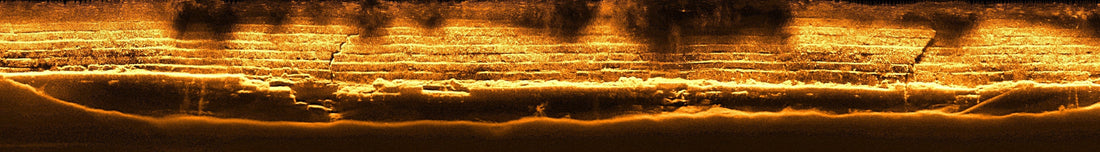
Multibeam sonar is one of the most widely used methods for high-resolution seafloor mapping. It works by emitting multiple sonar beams in a fan-shaped pattern, covering a wide swath of the ocean floor in a single pass. By analyzing the time it takes for the sound waves to return, scientists can generate detailed topographic maps of the seabed.
Multibeam sonar is especially useful for mapping underwater hazards, shipwrecks, and marine habitats, helping industries like commercial shipping and offshore wind energy plan their operations. New Zealand’s Cook Strait and Kaikōura Canyon have been extensively mapped using this technique to identify earthquake-induced seafloor changes and assess tsunami risks.
2.2 Light Detection and Ranging (LiDAR)
LiDAR is an aerial mapping technology that uses laser pulses to measure the depth and structure of shallow waters. Mounted on aircraft or drones, LiDAR can penetrate clear water to map coastal seafloors, reefs, and riverbeds.
LiDAR is playing an important role in New Zealand’s coastal resilience projects, particularly in mapping changing shorelines, erosion-prone areas, and seagrass habitats. It is also critical for assessing coral reef health and identifying sediment movement in estuarine environments.
2.3 Autonomous Underwater Vehicles and Remotely Operated Vehicles
AUVs and remotely operated vehicles are increasingly being used to conduct high-resolution seafloor mapping in deep and complex environments. Unlike traditional sonar-equipped ships, AUVs can operate autonomously, collecting detailed seafloor images, water quality data, and geological samples.
In 2022, New Zealand researchers deployed AUVs in the Kermadec Trench, one of the deepest parts of the Pacific Ocean, to study hydrothermal vent ecosystems and deep-sea biodiversity. This technology is also being used for subsea pipeline inspections and deep-sea mining assessments.
3. Applications of Three-Dimensional Seafloor Mapping
3.1 Marine Conservation and Biodiversity Protection
Detailed seafloor maps are essential for marine protected area management and habitat conservation. By mapping deep-sea coral reefs, seagrass meadows, and kelp forests, scientists can monitor climate change impacts, pollution levels, and invasive species spread.
New Zealand’s Hauraki Gulf and Fiordland National Park rely on three-dimensional mapping data to design and enforce sustainable fisheries regulations and ecosystem restoration projects. Advances in mapping also help researchers identify vulnerable species hotspots, such as endangered black coral and sponge gardens.
3.2 Offshore Energy and Infrastructure Development
Seafloor mapping is a cornerstone of offshore wind, tidal energy, and oil and gas exploration. Developers use bathymetric data to assess seabed stability, cable routing, and foundation placement for offshore structures.
With New Zealand’s growing interest in offshore wind farms, three-dimensional mapping technologies are helping identify suitable sites, minimize environmental disruption, and improve engineering designs. Studies in the Taranaki Basin and off the Canterbury coast are evaluating potential offshore energy projects using multibeam sonar and geophysical surveys.
3.3 Tsunami and Earthquake Risk Assessment
New Zealand is located along the Pacific Ring of Fire, making it prone to submarine earthquakes, landslides, and tsunamis. High-resolution seafloor mapping helps geologists monitor fault lines, underwater landslide zones, and tectonic plate movements.
The GNS Science-led Hikurangi Subduction Zone project is using three-dimensional imaging to study deep-sea faults and earthquake-triggered tsunamis. This research is critical for coastal communities in regions like Hawke’s Bay and the East Cape, where tsunami risks are high.
3.4 Fisheries and Aquaculture Management
Sustainable fisheries require accurate mapping of fish habitats, spawning grounds, and migration corridors. Three-dimensional mapping allows real-time monitoring of fish stocks, helping regulatory bodies like the Ministry for Primary Industries set catch limits and no-fishing zones.
Aquaculture farms in Marlborough Sounds and Stewart Island use bathymetric models to optimize farm placement, prevent habitat damage, and manage waste dispersal. Mapping is also helping the industry combat biosecurity threats, such as harmful algal blooms and invasive species.
4. The Future of Three-Dimensional Seafloor Mapping in New Zealand
The future of seafloor mapping will involve artificial intelligence-powered data analysis, cloud-based marine spatial planning, and real-time mapping technologies. Emerging innovations include machine learning algorithms to improve seabed classification and predictive modeling, cloud-based systems that allow researchers to access and update seafloor maps instantly, and international initiatives like Seabed 2030, which aims to fully map the ocean floor by 2030.
New Zealand is well-positioned to lead in these advancements, leveraging its expertise in marine research, ocean engineering, and environmental protection. The increasing availability of low-cost AUVs, advanced sonar systems, and open-source seafloor data will make high-resolution mapping more accessible for scientific and commercial applications.
5. Conclusion
Three-dimensional seafloor mapping is transforming our understanding of the ocean, benefiting conservation, infrastructure, and industry. The integration of multibeam sonar, LiDAR, and autonomous mapping technologies is providing detailed insights into marine ecosystems, natural hazards, and offshore developments.
New Zealand is at the forefront of seafloor mapping efforts, with ongoing projects supporting marine biodiversity protection, offshore wind energy, and earthquake risk assessments. As technology advances, the ability to map and monitor the seabed with greater accuracy and efficiency will play a critical role in sustainable ocean management and resource planning.
References
- Seabed 2030 Project – Global Ocean Mapping Initiative – www.seabed2030.org
- NIWA – Marine Geology and Seafloor Mapping in New Zealand – www.niwa.co.nz
- GNS Science – Hikurangi Subduction Zone and Tsunami Research – www.gns.cri.nz
- MPI – Sustainable Fisheries and Aquaculture Planning – www.mpi.govt.nz