Multibeam Sonar vs. LiDAR: Which Technology Is Better for Underwater Surveys?
Share
Abstract
Underwater mapping is essential for marine industries, environmental monitoring, and offshore infrastructure development. Two of the most advanced technologies for seabed surveys are multibeam sonar and light detection and ranging, commonly known as LiDAR. While both offer high-resolution data, they operate on fundamentally different principles and are suited to specific environments. Multibeam sonar uses acoustic signals to measure seafloor depth and structure, making it ideal for deep-water surveys, while LiDAR relies on laser pulses to map shallow water and coastal environments. This article compares the advantages, limitations, and applications of these two leading underwater mapping technologies and explores their roles in marine research and industry in New Zealand.
Introduction
Seafloor mapping is critical for industries such as offshore wind energy, commercial shipping, aquaculture, and marine conservation. Accurate underwater surveys help detect hazards, plan infrastructure, and monitor environmental changes. While traditional single-beam sonar was once the standard for underwater depth measurements, modern technologies like multibeam sonar and LiDAR provide much higher resolution and coverage.
Multibeam sonar and LiDAR both generate three-dimensional models of the underwater environment, but they use different approaches. Sonar is based on sound waves, making it effective in deep and murky waters, while LiDAR uses laser pulses, which are limited to clear and shallow waters. Understanding the strengths and weaknesses of each system is essential for selecting the most suitable technology for a given survey.
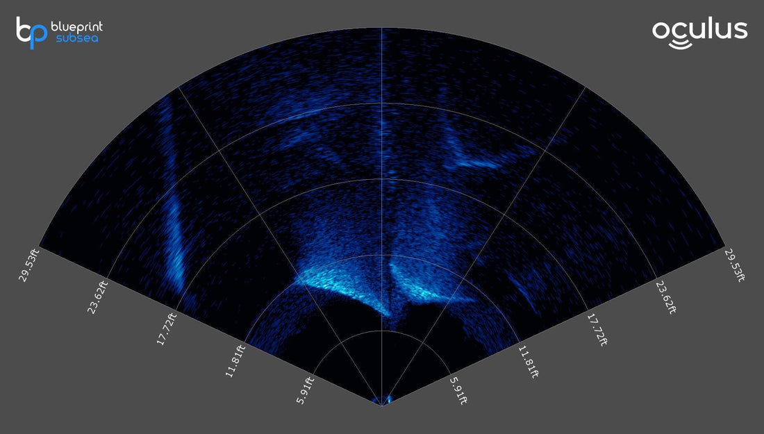
How Multibeam Sonar Works
Multibeam sonar uses sound waves to measure distances and create a detailed map of the seabed. A transducer mounted on a vessel emits multiple sonar beams in a fan-shaped pattern across the seafloor. These beams bounce off the bottom and return to the receiver, where the system calculates the time delay to determine water depth and seafloor contours.
Multibeam sonar systems can cover a wide swath of the ocean floor in a single pass, significantly improving efficiency over older single-beam sonar systems. The use of multiple frequencies and high-density beam arrays enhances accuracy and provides detailed three-dimensional bathymetric models.
Advantages of Multibeam Sonar
- Deep-water capability makes it effective in both shallow and deep-sea environments, making it ideal for mapping the abyssal ocean floor.
- Operates in low-visibility conditions, functioning in turbid, dark, and murky waters where optical systems like LiDAR fail.
- Wide area coverage captures large sections of the seafloor in one pass, making it highly efficient for surveying large areas.
- High accuracy in depth measurements provides precise bathymetric data essential for subsea engineering, offshore wind farms, and oil and gas exploration.
Limitations of Multibeam Sonar
- Resolution decreases with depth, and while sonar is effective in deep water, the resolution of seafloor details can decrease at extreme depths.
- Slower data processing requires post-survey analysis to refine depth measurements and remove noise.
- Requires vessel-based deployment, unlike LiDAR, which can be mounted on drones or aircraft.
How LiDAR Works
LiDAR, or light detection and ranging, is an optical remote sensing technology that uses laser pulses to measure distances. When applied to underwater surveys, LiDAR systems are typically mounted on aircraft, drones, or boats, sending laser pulses into the water and measuring the time it takes for them to reflect off the seafloor.
LiDAR is highly effective for mapping shallow coastal waters, coral reefs, and estuaries, as it provides high-resolution imagery in clear water conditions. Bathymetric LiDAR systems use green-wavelength lasers, which penetrate water more effectively than other wavelengths.
Advantages of LiDAR
- High-resolution imaging produces detailed topographic maps of the seafloor, especially in shallow coastal zones.
- Rapid large-area coverage scans vast areas quickly when deployed from aircraft or drones, reducing survey time.
- Useful for both land and underwater mapping, seamlessly integrating land and shallow-water surveys.
- Ideal for environmental monitoring, frequently used for coral reef assessments, sediment transport studies, and beach erosion monitoring.
Limitations of LiDAR
- Limited to shallow waters as laser penetration is greatly reduced in deeper waters, typically beyond fifty meters, making it unsuitable for deep-sea mapping.
- Affected by water clarity, working best in clear water, while turbid or murky water can scatter laser pulses and reduce accuracy.
- More expensive than sonar in some cases, as airborne LiDAR systems require specialized aircraft and high operational costs.
Comparing Multibeam Sonar and LiDAR
| Feature | Multibeam Sonar | LiDAR |
|---|---|---|
| Technology | Acoustic (sound waves) | Optical (laser pulses) |
| Depth Capability | Effective in deep and shallow waters | Best for shallow waters up to fifty meters |
| Water Clarity Impact | Works in all water conditions, including murky and dark environments | Requires clear water for accurate readings |
| Resolution | High resolution but may decrease with depth | Very high resolution in shallow areas |
| Survey Speed | Slower due to vessel movement | Faster when deployed from aircraft |
| Deployment | Requires ship-based transducers | Can be mounted on drones, aircraft, or boats |
| Best Use Cases | Deep-sea mapping, offshore energy, marine infrastructure surveys | Coastal mapping, coral reefs, shallow estuaries, beach erosion monitoring |
Applications in New Zealand
New Zealand’s Use of Multibeam Sonar
New Zealand has been a leader in deep-sea mapping, particularly in tectonically active regions like the Hikurangi Subduction Zone and the Kermadec Trench. Scientists from NIWA and GNS Science use multibeam sonar to monitor underwater fault lines, assess tsunami risks, and map hydrothermal vents.
The Cook Strait and Marlborough Sounds have been extensively surveyed using multibeam sonar to identify potential hazards for shipping lanes and offshore wind farm sites.
New Zealand’s Use of LiDAR
LiDAR has been widely used for coastal erosion monitoring, aquaculture management, and habitat mapping. The Ministry for Primary Industries uses LiDAR to survey seagrass beds, mangrove forests, and intertidal zones to track environmental changes.
Airborne LiDAR is also critical for assessing beach sediment transport, reef degradation, and coastal flooding risks. In places like the Bay of Plenty and Northland, LiDAR mapping supports marine spatial planning and climate resilience efforts.
Which Technology Should You Use?
The choice between multibeam sonar and LiDAR depends on the depth and environmental conditions of the survey site.
- For deep-sea exploration, subsea construction, and offshore energy projects, multibeam sonar is the preferred technology due to its ability to function in all water conditions.
- For coastal habitat monitoring, beach erosion studies, and shallow-water surveys, LiDAR provides higher-resolution data and faster coverage when water clarity allows.
- For projects requiring seamless land-to-sea mapping, LiDAR is the superior option, as it integrates with aerial topographic surveys.
Conclusion
Multibeam sonar and LiDAR each play crucial roles in underwater mapping, with sonar excelling in deep and murky waters, while LiDAR offers unmatched precision in clear, shallow environments. New Zealand’s marine industries benefit from both technologies, using multibeam sonar for deep-sea hazard assessments and LiDAR for coastal conservation and climate resilience planning.
As technology advances, the integration of artificial intelligence-driven data processing, real-time mapping, and hybrid sensor systems will further enhance underwater survey capabilities, ensuring sustainable management of marine resources and infrastructure development.
References
- NIWA – Marine Geology and Seafloor Mapping – www.niwa.co.nz
- GNS Science – Hikurangi Subduction Zone Research – www.gns.cri.nz
- Seabed 2030 Project – www.seabed2030.org